
Te Araroa: Queenstown to Telford Campsite

Harris Lake on the Routeburn Track
“When I reached Telford Camp, I was swarmed by sandflies. I breathed them in, I ate them, I slept with them, and some small part of me smiled because everything was so beautiful. I’d almost walked across an entire country, there were so few miles left. And what had I learned of suffering? To have the freedom to choose it was a gift. The most beautiful gift in the entire world.”
Day 92 (3/10/24): 19.3mi, +4709ft // 32km, +1436m
Queenstown to Greenstone Saddle Campsite via the Routeburn Track

I woke in the dark, stifling the trill of my alarm as quickly as I could. I was in a room full of sick people in a hostel in Queenstown and I had a bus to catch.
I’d spent most of the night paranoid about being shut indoors without fresh air, while 4 of the 7 other people in my bunk room were coughing and hacking, the deep rattle in their lungs intensely disconcerting.
To make matters worse, someone kept closing the window anytime I drifted off, and dialing back the blower on the wall by the door. I was in a snit about it all, and yet—somehow—I managed to drift off in the wee hours of the morning.
My gear was arranged exactly how I always arrange it for early morning departures from hostels, set neatly for me to finish packing up quickly and in the dark, so that I caused minimal disruption and left nothing behind. I changed into my hiking clothes and stuffed my fleece, long underwear, headlamp, charging cables and Kindle into my pack, then I was off.
My stay in the chaos of Queenstown was decidedly brief, ultimately I was glad I zeroed in Wānaka.

Look at that highway of a trail! So Smooth.
On the bus ride to the start of the Routeburn track—a bonus adventure, not part of the TA—I sat next to a woman from Wellington who’d backpacked this particular Great Walk 5 times. She said it was the most beautiful hike in New Zealand. I had chosen to include the Routeburn in my walk because it added miles to my adventure, not subtracted, and there was no “trail” around Lake Wakatipu—the TA ended on one side of the lake and picked back up on the other—and this lake, being that it is 112sqmi, is really quite big.
By including the Routeburn, I would take a bus to the north end of the lake and then hike southwest back to the TA.

Disembarking the bus with hoards of other people, all headed to roughly the same place I was turned out to be a little stress inducing. I did not want to get stuck behind a slow moving crowd, so I collected my pack and immediately set off up the trail.
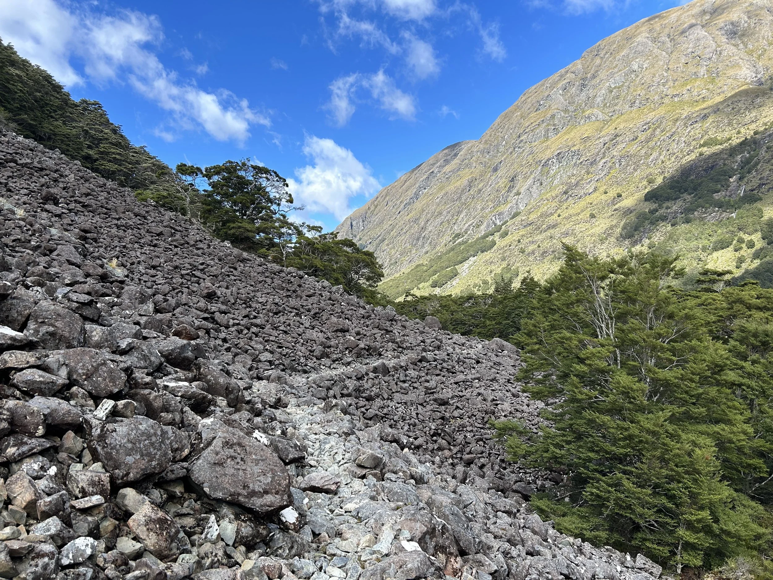
The view of the Routeburn River Valley along the way to Routeburn Falls was breathtaking. The landscape of Fiordland-Aspiring National Park was humbling and inspiring, I had never walked across a place as magical and otherworldly.

At Routeburn Falls I took a snack break and switched out the battery in my GoPro—the GoPro was on its last legs—as I ate, I stared absentmindedly at the thundering falls.
Water from the falls cascaded over a series of ledges covered in moss and delicate vegetation, the whole scene felt rather Faye. And maybe that is why I described so much of New Zealand as magical in my journals, its environment seemed to percolate with unknown—perhaps limitless—potential. A land scape that inspired wild ideas and dreams.

Beyond the falls, the trail snaked into the alpine. A haze of white clouds tickled the surrounding peaks and draped gossamer tendrils over their shoulders. Weather was predicted to roll in that afternoon, but for now the clouds did not obscure my view.

At a certain point my jaw fell open and stayed hanging that way for the rest of the day. There was a reason why the Routeburn was a Great Walk, why people came from all over the country and the world to walk it; really, no stretch of trail I’d walked thus far could quite rival its beauty, and that is saying something.
Water poured from every surface, streams gurgled and creeks ran crystal clear, springs burbled forth from between bunches of tussock and spear grass.

And then I reached Harris Lake and saw Troll Valley just beyond it, and I wondered if at some point I might go blind from seeing, if my brain might stop processing the constant inundation of stunning visuals.
I stared at the steel-grey surface of the lake and thought if I waited long enough, a dragon might burst from the steaming clouds up valley and perch on sharp talons above the horsetail waterfall; I wondered, too, if an army of goblins wearing golden armor wielding swords of gleaming silver might march against their winged foe to steal the treasure it guarded.
And when I got tired of imagining, I, myself, marched on.

The rest of the afternoon was equally inspiring, but after I stopped for lunch it was clear the weather would eventually turn sour, so I quickened my pace down to MacKenzie Lake—a favorite spot for visitors to camp, as the Hut was supposed to be incredible, but also nearly impossible to book a spot in. Due to the competitive nature of bookings along any Great Walk, I opted to hike the Routeburn straight through in a single day.


Mossy forest giving ethereal vibes on the way down to MacKenzie Lake

The Hut (more like hotel!) at MacKenzie Lake
Eventually the sky clouded over completely and made the icy glaciers clinging to distant peaks appear quite cold and foreboding.
I ran into Keenan—rather, he almost tripped over me—while I was eating gummy bears alongside the trail. He confessed he’d been trying to catch me all day as a personal challenge, so we decided to hike together the rest of the way to the free campsite at Greenstone Saddle.
The company was nice, we chatted about trail and about how he stealth camped just above Queenstown the night before on the ski resort, a brave move in my opinion. He definitely got better sleep than I did in my hostel, either way. I’m always so afraid of getting caught camping in places I am not supposed to, which usually results in me spending more money on accommodations than I want to.

The final stunner of the day was a waterfall neither of us was expecting…

We had to crane our necks to glimpse its origin far, far above us, it seemed as though the wall of rock and hanging mosses might have gone on climbing forever into the heavens.

It began to rain shortly after we made camp in what was probably a cow field at certain times of the year. We cooked dinner together in the weather and Keenan told me he hoped to meet a vegetarian girlfriend, that it was really important he have a partner who shared his views on health, the environment and animals.
I was too tired to feel self-conscious about my cheese filled ramen bomb, or that I’d packed out some bacon to add to it. Hunger was the only thing on my mind. But I wished him luck on his quest, all the same.
As I lay down in my tent, cozy and dry amid the gale force wind and rain, I thought the end was getting too close, I wasn’t ready to be done with Te Araroa.
Day 93 (3/11/24): 15mi, +1419ft // 25km, +432m
Greenstone Saddle to Greenstone Hut

Hiking the Greenstone Track to rejoin the TA the next day made me absolutely feel like I was ready to be done with Te Araroa. I cursed and griped as I tripped over rocks and roots and sank into bogs and stumbled blindly through tangles of tussock. I was exhausted, my pack felt heavy as lead, and the miles ticked by with painful slowness.
In my journal I wrote:
“My brain felt dumb and slow from two nights of bad sleep; exhaustion permeated my whole being. I wanted to lay in my tent and stare at the ceiling all day, instead I spent the day walking on hard-to-follow track, slick with mud and got lost several times in waist high tussock and sharp stabby bushes.”
I wish I had more positive things to say about the Greenstone Track, I might have had some, but on the heels of the Routeburn nothing quite compares.

The forests were beautiful, I will say that much, and I saw an impressive rainbow, which has to count for something.
After a night of rain and morning of intermittent showers, the sun finally broke through the clouds with force and turned the world around me into a steamy sauna, filled with a disappointing number of sandflies.
Everything felt hard. I chased patches of sun in an attempt to dry my gear out, but failed every time; there was no breeze to speak of, and despite the sun, the air was far too muggy for evaporation to occur. The sandflies were so thick, to stop walking was death, anyways.
I’d had such a nice break from the vampires prior to Queenstown, but now that the trail bent further west, closer to the fiords, I was back in biting distance.

The trail alternated between forested sections, scree fields, and seas of tussock, which kept things somewhat interesting (she said unenthusiastically).

But any time the trail left the forest I quickly lost it in the tussock. Sometimes the orange markers weren’t very apparent from one to the next, and like I’d written in my journal, my brain felt dumb and slow.
Among the trees my slow pace enabled me to study the plush moss beds and delicate ferns, the electric lichen and twisting canopy of branches.
The rest of the Greenstone track unfolded predictably—forest-valley-tussock-mud-cowpie-repeat.

I had hoped to grind on, past Greenstone Hut, but alas, my day ended there. It was probably for the best, I wasn’t enjoying the walk that day and there was no sense dragging on further with the mood I was in.
I found a cozy spot in the trees behind the hut to pitch my tent and then I proceeded to lay in it for the rest of the afternoon. When I made my way into the hut to cook dinner, there was a DOC ranger inside. He asked if I was the one camping in the woods, I said yes, I was.
“There’s going to be a big storm tonight and it’s not safe to camp in the trees, they fall down very easily and frequently. Didn’t you see the sign?”
“I must have missed it. But I just pulled the weather on my InReach and the night is supposed to be clear with no wind.”
My contrariness seemed to perturb him but I was too tired to even think about moving my tent. And since I wasn’t breaking a rule, only potentially endangering myself and my tent, he couldn’t make me move.
How many nights had I camped among trees with shallow roots and survived?
He told me a tree was definitely going to fall on me, then left the kitchen area for his bunk. I sat down and made what felt like my millionth ramen bomb, without a care in the world.

Spoiler, I didn’t die. There wasn’t even a breeze that night.
Day 94 (3/12/24): 24mi, +3015ft // 40km, +919m
Greenstone Hut to Unofficial Campsite along North Mavora Lake

Of this day I wrote:
“I am not sure I have the mental stamina to deal with another day like today.”
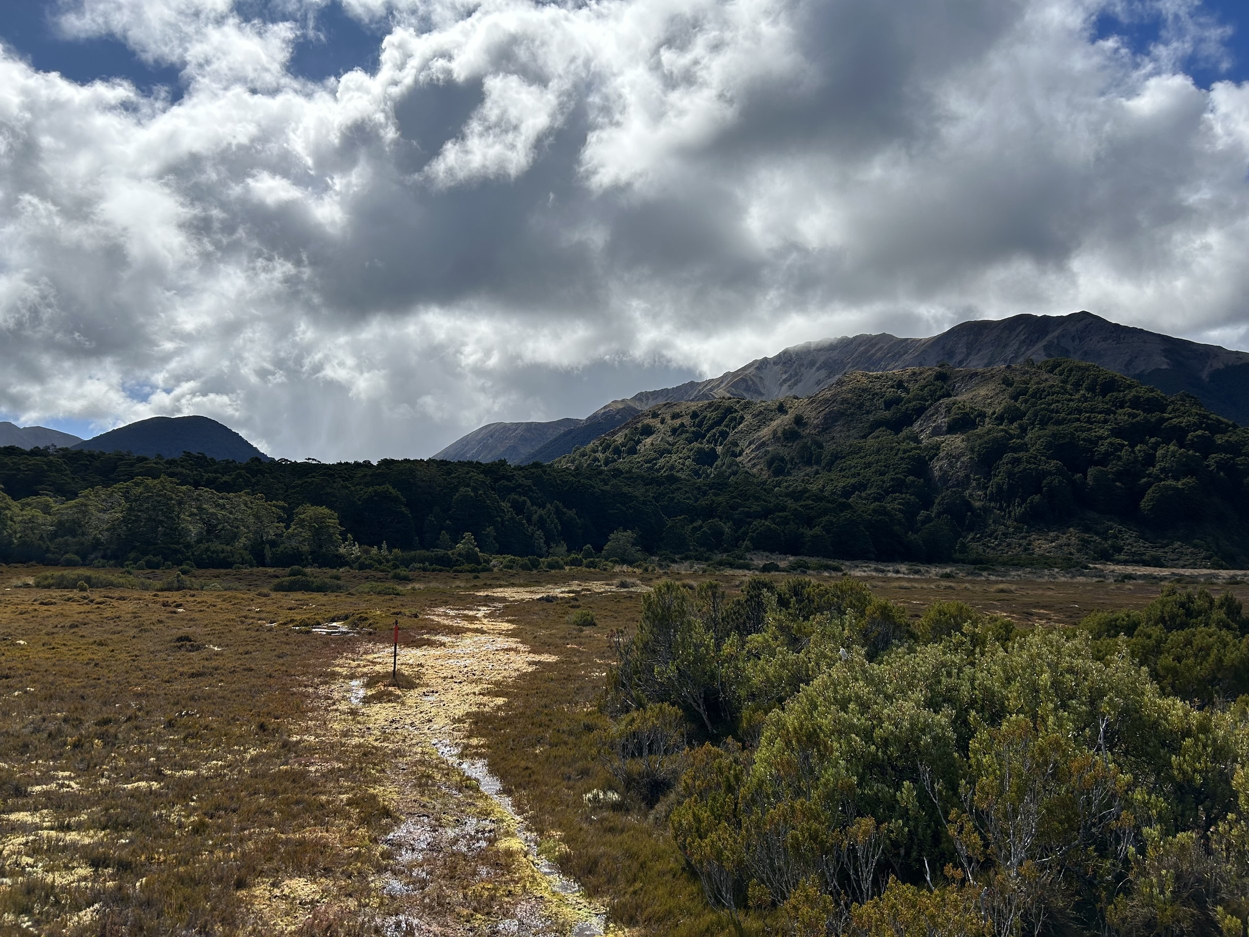
And now here are some lovely photos that don’t at all match the level of struggle I encountered on the Mavora Walkway aka “the Bogs of Mavora” aka Sandfly Hell aka “The Dead Swamp”. So, yeah, not an easy day of walking and 24 miles felt like a huge ask. But it was beautiful.

The views were spectacular, though I found it hard to look at them and walk at the same time. The ground was horribly uneven and there was a fifty fifty chance a seemingly firm step might turn into a gaping, bottomless hole.
The route linked up a series of alpine peat bogs, which were fascinating to experience, especially as intimately as I experienced them. Storms rolled in all around me like waves riding a tide, coalescing into the thickest of gray ceilings and then dissipating just as quickly to reveal blue sky.

I tried to connect with gratitude and scrutinize my self deeply, to understand why I was struggling so hard on this day. I knew I was lucky to be where I was, but 94 days of walking had left me with very little gas in the tank. I wondered absently if I was getting my period soon, which would explain my irritability and fatigue, but then I fell in another bog and got mad and decided “the trail was being so unfair” and then railed against the universe with a “why couldn’t the walking just be easy for once?!”.
As I pulled myself out of another moss-hidden mud-hole, I decided the Mavora Walkway was more of a wade-way, as it seemed to be mostly water.
At one point my foot rolled off a slippery log I was trying (and failing) to balance on, and as I attempted to spare myself the fall, I splashed mud into my eyes, painfully so.
Later but not much later, I pulled my rain pants down to pee, sandflies flew inside before I could pull them back up and then proceeded to bite me for the next 2 miles. There was nothing I could do besides slap at my legs like an idiot, because the risk of pulling my pants down to get the demons out was that even more would get in.

I think on some level I knew that this wasn’t the worst it could get, that things might, in fact, only get worse from here. And you, reader, might be thinking, “Oh Jeez, will she ever stop complaining?” The answer is yes, periodically, then I might fall into another mud pit and, well, you get the picture.
I was existentially tired. Okay?

My luck was good, though, despite conditions underfoot. I made it to Boundary Hut just in time to dodge a vicious squall, and waited it out to the tune of gummy bears and dried mango slices. I’d already dodged a previous squall at Taipo Hut, so I said a silent thank you this time to the weather gods, and hunkered down until the wind abated and the clouds parted.

The rest of the miles that day were on a 4X4 track, easy walking comparatively, except that the dirt road was full of crater-sized holes of viscous brown water, and if I didn’t want to go for a swim, I had to hike into the tussock and Matagouri to avoid them.
I knew now that my hope prior to Queenstown, that I’d seen the last of the sandflies, was naive. And realizing that while standing in six inches of mud, on a wiggling water mattress of grass and moss, legs and butt maddeningly itchy, it felt like a slap in the face.
I had no one to blame but myself, though. After the sandfly hell prior to Arthur’s Pass Village, I told myself a pretty lie to put my brain at ease—no more sandflies, all you have to do is survive these miles, then you’re in the clear—and I’d really believed it.

What 90% of the day looked like underfoot

A relatively dry sea of Tussock

Taipo Hut

Do you see the trail? I didn’t.

The AT catch phrase was “Embrace the Suck”; I think the TA catch phrase (at least on this day) needed to be “Embrace the Muck” because there was plenty of it.

Pretty white bones, somehow not muddy at all.

When North Mavora Lake came into view, I was ecstatic, as ecstatic as a zombified, mud coated, fly bitten human can be.
Looking back now, this day on trail was maybe one of the most aesthetic, despite my grumpiness. The grey skies brought the landscape to life in an ominous way, and though I struggled with fatigue and irritability, I remember this day vividly, as vividly as the Routeburn.
Maybe I remember it so well because of all the discomfort, after all, I did fall into a sharp bush, get mud in my eyes and sandflies in my pants, and narrowly avoid two pelting squalls.
I’ll never forget the Mavora Walkway.

I took an exceedingly longtime to pitch my tent that night. I cleared sticks and debris from one spot, then decided I didn’t like the look of the trees above it, worried they might come crashing down on me like the ranger at Greenstone said they would.
I moved my tent at least five times, sighing grumpy sighs, until I decided I didn’t care if I died underneath a tree as long as I didn’t die in a hospital bed or get bitten by another sandfly that night.
Looking ahead at the next day of walking stressed me out, so I didn’t bother studying it for long. Apparently the trail would be good for about 10 miles, then deteriorate rapidly into a bushwhack pressed against a barbed wire fence and involve a sketchy river crossing. The alternative was to walk a gravel road.
In that moment I decided it was most important to find a way to enjoy my hike, and if that meant opting for the gravel road walk, that was okay. I knew I needed to throw myself a bone and find a way to get my head on straight. A little flexibility went a long way when walking 3000km.
Day 95 (3/13/24): 29mi, +921ft // 48km, +280m
North Mavora Lake to Te Anau Top 10 Holiday Park
(Te Anau is roughly pronounced: Tea Ah-Now, just incase you were curious!)

I woke up in a better mood, ready to enjoy the day no matter what challenges it presented me with. My tent hadn’t gotten crushed by a tree despite all the wind over night, and I had a new lease on life.
It was bitter cold just before dawn, as it tended to be now, well into Autumn as I was. I crossed the southern outlet of N Mavora lake on a swing bridge, and entered into a world of soft mosses and bright red Amanita mushrooms, dew still clinging to the white buttons on their caps.

South Mavora lake steamed when the sun kissed its surface, and the scene was peaceful.
At the swing bridge before the Mavora River I kept right, on the TA, deciding to stick to the true trail for another 9km, even though the trail notes mentioned a lot of blow downs and slow travel. I planned to walk the gravel road later in the day, but I wanted to spend as much time in the woods as possible before then.

Bridge over the steamy Mavora River

Perky mushroom in soft green moss
For two km the trail was smooth sailing, then I hit the cataclysmic blowdowns. The felled trees were so extensive and tangled, I had to hike way up or downhill, far away from the trail, and then quite a long ways around, each swath of total annihilation. The destruction all around me hammered home the truth of the DOC ranger’s words. I probably could get crushed in my tent under one tree or many, and it wouldn’t even be that surprising—statistically speaking—I’d definitely be surprised.
I took my time navigating the downed trees and all their sharp, broken branches, tuning into the bird song and enjoying my view of the tumultuous river running steeply just below the cliff, off to my left.


When I reached the swing bridge across the Mavora River—a viable exit onto a gravel road leading to Te Anau—I dropped my pack and walked over to the bridge to get a view of the river. It appeared to be raging, and while the spot I would cross it on foot further on was probably fanned out and shallower than what I was currently looking at, I feared walking all the way there and then not being able to ford safely. The fact I was alone definitely came into play when making decisions about river crossings.

The torrential Mavora River
I turned away from the bridge and walked back over to my pack—to my surprise, I had a visitor!
Toutouwai perched on my pack in all his bossy glory (I knew it was a he due to the darker grey head and neck and creamy white belly). The South Island Robin is a caricature of a bird with its long, stick-like legs, large rounded head and tiny pointed beak. His voice is big and boisterous and sounds much like his name, “Tou Tou Waiii”.
He didn’t move as I came over and sat down next to my pack, once I was settled, he hopped to the ground next to me, then popped up onto the toe of my shoe and down to my leg. I was in awe.

A male Robin (Toutouwai) perched on my smelly pack
Later I would learn that many of these birds waited for humans to rough up the soil so that they could hunt for little worms hiding under the duff. Perhaps that is what this one hoped for. Ultimately, though, he seemed content to supervise my lunch and pick sandflies from the air around me. A service I was exceedingly grateful for.

I’m not sure if Toutouwai was a sign, or if his visit meant anything significant in the grand scheme of things, but I decided to play it safe and walk the gravel road. It was a long and hot walk, but I was fully immersed in the third Mistborn book in the trilogy, and when the story ended a mile or so from the road leading into Te Anau, I cried.
Brandon Sanderson had built a beautiful world full of characters I felt I truly knew, and though the ending was beyond perfect, I was sorry it was over.
I decided to take a zero day in Te Anau, a small, touristy town which served as an access point for the Kepler Track, another Great Walk. I figured much of my struggle since the Routeburn had to do with fatigue since my last day off was in Wānaka, and I wanted to take some time to really plan out the last week + of my hike.

Pad Thai in Te Anau
Day 96 (3/14/24): zero day
Top 10 Holiday Park, Te Anau
I made eggs for breakfast at the Holiday Park, and called Logan to catch up.
Keenan also made it to Te Anau last night and he very kindly shared his campsite booking with me for both nights. It seemed like the holiday park would allow as many tents as possible to be pitched on a single site, so long as they could keep charging for additional guests. It was a nice Holiday Park, though, very close to restaurants and a grocery store.
I did every chore I could think of—ATM, resupply, bought new insoles for my shoes—and spent the rest of the day relaxing at the Holiday Park. When I considered how far I’d walked, and the comparatively short distance I had left to go, it was really quite amazing.

Nearing the end of my journey on Te Araroa
Day 97 (3/15/24): 14 mi, +3084ft // 23km, +940m
Te Anau to Aparima Hut

I scheduled a shuttle for 9AM, figuring it would be trickier to hitch a ride back to the trail than it was to hitchhike from the trail into Te Anau—which hadn't exactly been easy. A leisurely departure time allowed me to treat a growing problem with my feet using some Lotrimon (athlete’s foot cream).
The webbing between my toes was so irritated and inflamed, and the itching was incessant. I truly thought I would lose my mind from the pleasure/pain of scratching my toes raw. The cream helped sooth the fire, but I had to reapply way too frequently to make any real difference.
It had rained all night so I’d been forced to pack my tent up wet, and it was spitting rain now, as I walked to grab a coffee from the Waipiti Cafe post-foot treatment.

Keenan wound up joining me for the shuttle, forgoing his plan to hike the Kepler Track due to bad weather being forecasted. He said he’d come back for it after he finished the trail, he planned to take some time to explore more of New Zealand before returning home to Colorado.
When we were dropped off at the gravel road we’d both hitched into town from two days ago, Keenan hung back to chat with some other hikers he knew; I took off at a power hike, eager to cover the 3.7miles of gravel road to Princhester Hut, and get back into the woods.

I knew the Takitimu Forest would be hard, slow-going, full of mud and confusing tussock bogs. I was prepared for the steep, overgrown trail. What I wasn’t prepared for was just how beautiful the forest was—ethereal, whimsical, enchanted, bewitched.
Moss clung to the beech trees, draping delicately over their twisted forms; the beeches’ bark shone silver in the grey light and lichen, electric and celebratory, clung vibrantly to their trunks. Seas of ferns swelled around me like oceans unto themselves—some of their waving branches were as tall as me—and Titipounamu trilled, blessing this sacred place, from the canopy above.
I felt part of something huge and intricate and expanding. I felt like I belonged in my body and in the place where I stood.
I heard the echoing call of Korimako, though I couldn’t yet name it, and realized—as I sometimes do—that if I did nothing else in my life besides hike through, I would have lived well.

The forest continued to be stunning as my day slowly progressed.
Occasionally the trail exited the trees and sent me forth into a maze of golden grass, so tall that when I blinked, strands of tussock were caught between my eyelids and pulled painfully through their delicate pink skin with every step I took. A truly uncomfortable experience.
I couldn’t see where I was going at all, not even 3 feet in front of me, let alone the next trail marker. My feelings of claustrophobia abated in the forest though. Any time the route took me into the trees I felt my blood pressure drop and my breathing slow, mud be damned, at least I could see where I was putting my feet. And the birds, the birds kept me company.

I fell into several creeks obscured by tussock, and a couple hip deep potholes too, which yawned cavernously beneath me, out of no where, to swallow me whole. There is something quite humbling about stepping down into a hole of unknowable depth, with strands of grass caught in your eyes and mud all over your hands, pants, and face.
I averaged about 2miles per hour all day, which by the standards of many is quite fast, given the terrain. To me, it felt quite slow, but not unenjoyable.

I arrived to Aparima Hut early in the evening, and quickly realized it was more than full. Tents were pitched in the yard space around the hut, and what seemed like 12 pairs of boots were set out on the porch to dry—though I suspected at this point they were more likely to freeze solid.
Choosing to pitch my tent near the edge of the woods, but not directly under any trees, felt like a good call. There was no where to camp fully away from the other tents, so I steeled myself for having potentially noisy neighbors. Some of the men staying at the hut looked like they might be heavy snorers, it was just a feeling I got, and I was right.

Several other thru-hikers rolled in after me: Cassie, Keenan, Rebecca, Anna, and a French couple I hadn’t ever met before, and we all made dinner together in the the annexed hut that Rebecca and Cassie claimed as theirs for the night. It was bitterly cold and damp outside, and the hut provided some warmth as we all chatted and commiserated and exclaimed over the day.
While I am not a social hiker, I do appreciate having the option to connect with other walkers, especially after a long day. Emphasis on the word “option”.
I’ve wrestled with a lot of feelings and thoughts regarding the interactions I have with other people while on trail. I beat myself up for my resistance towards ever joining a trail family, for my inability to connect and stay connected with other hikers while on trail, for my ultimate feelings of repulsion towards a person or group I’ve hiked with for too long.
I seem to have this deeply rooted need—compulsion, really—to be alone, really and truly alone, when I am walking.
Many hikers will tell you people are their reason for setting out on a trail, and while trails have brought many people—and a few really important ones—into my life, people are never my reason for going. My heart is made full by other things.
In this photo it looks like there was something white and reflective in the peat moss—that is water, sometimes knee deep. The ground was never as firm as it seemed.
Day 98 (3/16/24): 13.5mi, +4209ft // 22.5km, +1283m
Aparima Hut to Telford Campsite

The southern half of the Takitimus proved to be a brutal stretch of trail, reminiscent of both the Richmond Ranges and the Raetea Forest. As the New Zealanders would say, the hiking was slow as.
I moved like there were cement blocks attached to my feet, and like my pack weighed a million pounds, which it did.
There was an icy cold bog walk to start, then straight back into the forest for the rest of the day. I was fully bundled for the morning portion of my hike, but it did nothing to warm my frozen feet. It was impossible to avoid the wetness, and trying only slowed me down.

Once I entered the forest for good, I felt relief. Happy to be finished with the cold, exposed bogs. I made the mistake of listening to a depressing apocalyptic novel for well over 3 hours, first thing in the morning, which made my feet feel even heavier than usual, like they toted cinder blocks. The depressing narration caused my pack to feel even more oppressive than it usually did. The book was How High We Go In The Dark—yes I finished it, no I don’t recommend it.
Eventually I took my earbuds out and listened instead to the forest. It was entirely peaceful. Not even the ferns whispered to one another. The silence only broken by a singular shout from Toutouwai, an indiscernible command echoing through the trees.

It took me 4 hours and 15 minutes to reach Lower Wairaki Hut, the first hut since I’d left Aparima that morning. DOC had estimated the 8 miles would take 8 hours, and I’d almost halved the time but it still felt slow. I ate lunch inside the hut, which was full of mud, and readied myself for the next stretch to Telford Camp.
The distance to Telford was only 5 miles, but DOC predicted it would take another 8 hours. That seemed insane to me, how could the trail possibly get any slower? I was already struggling to move 2 miles per hour, but then, there was a much bigger climb ahead, so perhaps that was where the extra time came from?
I suddenly felt I was back in the Richmond Ranges, preparing for the strenuous hike along the Wairoa River, or back in the Raetea forest, even, ankle to knee deep in thick, viscous mud.

The climb up and away from Wairaki turned out to be a bear. I couldn’t tell if I was climbing a single mountain or up the humped shoulders of many, so dense and tightly wound around me was the forest.
Thick moss clung to every surface, the air felt overly saturated—liquid, almost—but without any rain. I became more of a swimmer than a hiker, pulling myself through space with long leg strokes through mud and duff.
I moved like a machine, I was addicted to the climb; my breathing loud and raucous, my body hungry for vertical gain, my legs burning from the sustained incline. I seemed to sustain this level of intensity for hours, but maybe it was only an hour.
The forest began to thin, revealing a grey ceiling of clouds and an unnatural brightness. Another step brought me above tree line.

And suddenly the world opened. I could see for miles in every direction—I could breathe again.

Oh, how I loved a ridge walk. And this one felt like such a gift after toiling for so long among the trees. Supposedly you could see Bluff from here, but I wondered if the cloud ceiling might be too low for that.
I took a break on a rocky outcropping and popped my shoes off. I reapplied the anti-itch cream in between my toes and then ate a tortilla filled with chips and cheese, and some dried mango, separately, of course. Camp was not far away now, the climb was definitely the arduous portion of the hike from Aparima, and I was grateful to have it behind me.

I thought for a moment about how I’d come to be here, among the clouds and the scrub and the lichen and the moss, covered in dried mud with hair on my legs and a fungal rash between my toes. And how happy I was. How tired I was. How full and unsure and in awe I was.
I didn’t know how beautiful life could be. When I was still drinking and using I never allowed myself to see. I didn’t want to be emotionally uncomfortable, so I lived in a constant state of distraction—I lost myself. But beauty is multifaceted and complex, it’s sharp edged and shot through with pain and bitter discomfort, it’s often ambiguous and hard to recognize. It exists on the other side of, and in conjunction with, uncertainty and the unknown.
What I wish for every addict not yet in recovery is time. Time to make a small amount of peace with what haunts you. To realize beauty and purpose and meaning frequently hold hands with misery. You can’t pick and choose what you feel, but if you open yourself up to the unpleasantness and pain, both inside of yourself and all around you, beauty will find its way in, too.
As I write this I’ve been sober for 6 years, and the greatest lie I was ever told pre-sobriety was that life was supposed to feel good, be comfortable, and unfold easily for me all the time. It is not. But everyone selling something will tell you it is.
I understand why a person might be desperate to feel nothing, sometimes the bad is just too big, and I understand why addicts’ behavior is infuriating for the people who love and care about them. And. I now understand there is no simple solution, no forever fix, the path to recovery is not a straight one. There is no map because there is no destination. The journey is everything, and the only thing, that matters.
All anyone can wish for someone who is struggling with addiction is time, time enough to find their way.

When I reached Telford Camp, I was swarmed by sandflies. I breathed them in, I ate them, I slept with them, and some small part of me smiled because everything was so beautiful. I’d almost walked across an entire country, there were so few miles left. And what had I learned of suffering? To have the freedom to choose it was a gift. The most beautiful gift in the entire world.